
By Kate Burns
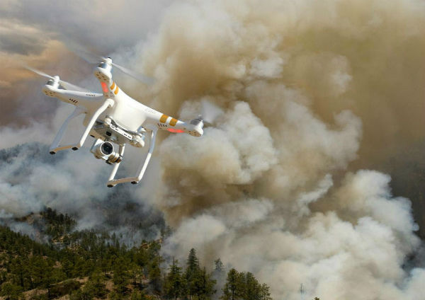
Of the more than 30,000 wildfires in the United States this year, there have been more than 15 drone intrusions that have affected firefighting operations in California, Arizona, Utah, Nevada, Alaska, Minnesota and Montana. Unmanned aircraft systems (UAS) have become quite the problem for firefighting planes and helicopters recently. The drones fly low and slow in smoke-obstructed areas, and pilots are too busy releasing water and fire retardant to notice the UASs in their way. With drone intrusions nearly doubling from 2014 to 2015, firefighters are taking a stand.
The Department of the Interior has put plans together for a real-time alert system that has a geofencing alarm to prevent against drone pilots interfering with firefighting efforts. The Department of the Interior has partnered with DJI, the largest manufacturer of unmanned aerial vehicles in the U.S., along with leading providers of airspace intelligence, AirMap and Skyward, to create this breakthrough idea.
“This pilot project makes initial wildfire location data publicly available to commercial mapping providers that support UAS operations, alerting drone pilots before they enter air space over an active wildland fire,” said Mark Bathrick, the director of Interior’s Office of Aviation Services, in a press release.
Also with help from the Federal Aviation Administration (FAA) and the U.S. Forest Service they have adopted an approach method, awareness campaigns, and protocols for notification so that our communities are safe and our firefighters are able to do their job. With the recent Saddle Fire in Utah, incident managers had to suspend aerial support to firefighters five times because of the intrusion of drones. Incidents like this are creating more harm than good. Campaigns such as “If You Fly; We Can’t” and “B4UFly” are creating a greater awareness for the harm that has come to firefighters and incident managers.
This new alert system has hopes to have the capability to prevent drones from operating in these restricted airspaces once they reach the geofence as well. Bathrick said, “No responsible drone operator wants to endanger the lives of the men and women who work to protect them and we believe this program, which uses the global positioning system to create a virtual barrier, will move us one step closer to eliminating this problem for wildfire managers.”
For more information on the DJI’s geofencing visit dji.com/flysafe/geo-system. More information on AirMap and Skyward airspace intelligence services is available at airmap.com and skyward.io.


