BY LAINE SEATON
Looking out over the vast expanse of the deep blue waters of Lake Pleasant, it’s hard to imagine the complex forces just below the surface, battling to ensure that Arizona will have enough water for future generations.
Nestled in the northwest corner of the Valley, Lake Pleasant is just one of 128 lakes throughout the state, enjoyed by millions of locals and tourists each year. It drew nearly 1.2 million visitors last year, many seeking fun recreation or a much needed escape from the scorching summer heat.
But in the last few years, lakes across Arizona and the Southwest — Lake Powell and Mead in particular — have been in a troubling spotlight, revealing the alarming and undeniable impacts of a decades- long megadrought, climate change, and conservation measures that have been rendered inadequate.
Old, rundown fishing boats, long hidden beneath the waves, were suddenly found randomly perched on dry rocks, and also striking was Lake Mead’s infamous “bathtub ring” band of white around its perimeter, which showed a drastic change in water levels that had dropped to just 27% capacity — it’s lowest level on record. What followed was a Tier 1 water shortage declaration, forcing states to cut back. But how did we get here?
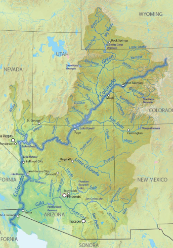
To better understand Arizona’s lakes, you need to start at the beginning and the mighty Colorado River. Along its expansive 1,450-mile stretch, winding through seven states from Wyoming to Mexico, the Colorado River is a major water source for many of the western states, serving 40 million people.
Built around a framework of Upper Basin states (Colorado, New Mexico, Utah, and Wyoming) and Lower Basin states (Arizona, California, and Nevada), the river’s water allocation was first established in 1922 through the Colorado River Compact. In simple terms, the Upper Basin states primarily get their water directly from the Colorado River and its tributaries, whereas the Lower Basin states get their water primarily from Lake Powell and Lake Mead, which are fed by the Colorado and its upstream tributaries. Arizona receives roughly 35% of its water supply from the Colorado, with the rest coming from groundwater, in-state surface water (like the Salt and Verde Rivers) and reclaimed water.
Keeping this essential water flowing has required extensive collaboration between the United States Bureau of Reclamation (the lead agency responsible for managing the Colorado River system), local municipalities, and numerous public/private entities, along with complex planning, massive infrastructure via dams and canals — think Central Arizona Project (CAP) and countless conservation strategies. But these collective efforts have been pushed to the limit by record-setting temperatures, conservation measures that aren’t cutting it, and the new reality caused by climate change that is sounding the alarm. “We’ve been in a structural deficit where we’re pulling out more water than can be replenished,” notes AZ Water Association President Alan Forrest. “Back in the 1920s, our water allocations were set during a time whenthe flows into the Colorado River were at their highest levels, but it’s obviously different now. The ongoing drought, climate change, and water use decisions have all played a part in our current situation, and it’s going to take time to get out of it,” he says. Sarah Porter, director of the Kyl Center for Water Policy at Arizona State University, cautions that this “structural deficit” is a “huge driver of declining reservoir levels.” The term refers to both the gap between supply and demand, and to a lack of accounting for water that is lost due to evaporation when it’s moved through a big system.
A NEW REALITY
If you turned on the news in 2021 or 2022, chances are you saw the widespread stories of historic drops in the water levels at Lake Mead and Lake Powell. Grisly reports of bodies being found in Mead’s lakebed only added to the drama. But behind the intrigue, the plunge in the lakes’ water levels in 2021-2022 was a serious tipping point, culminating from years of declining water levels going back to 2000. As hotter temperatures became the new normal, drier winters and lighter snowpack levels made it nearly impossible to replenish the amount of water that was evaporating or being used every year. And despite winters where snowpack levels have been robust, experts say that warmer temperatures and longer, drier seasons are weakening the amount of water the snowpacks would normally deliver. “The Colorado River is a snowmelt driven system,” says John Berggren, Regional Policy Manager for Western Resources Advocates. “We’re seeing more precipitation fall as rain rather than snow, and the snow we do have is melting earlier and more water is being absorbed by the soil, which means less water in the system overall.”
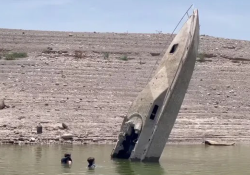
According to Porter, “Decades of below average flows compound the structural deficit, resulting in declining reservoir levels.” Measures to help mitigate these impacts through strategic water distributions and more intense conservation efforts, although helpful, have proved to be no match for the megadrought that has now lasted for nearly 25 years.
As a stark example, in the summer of 2021, millions of gallons of water from Colorado’s Blue Mesa Reservoir were released in an effort to shore up a depleted Lake Powell to the south. Already at a strikingly low 32% capacity, the reservoir’s two main marinas were forced to close three weeks early. 2022 was even worse, with an emergency order that the marinas close for the entire season, causing serious financial and economic ramifications. Closer to home at Lake Pleasant, boaters have also
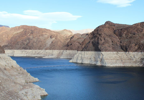
felt the impacts of fluctuating water levels. Although water levels at Lake Pleasant regularly fluctuate due to its function as a CAP reservoir, the topic of drought is top of mind for many. Lake Pleasant Harbor Marina Manager Joe Evans says, “When the water levels drop, the available boating surface starts to shrink. He continues, “Islands that are 20-40 feet underwater actually start to appear. The drought is always looming in our thoughts, and we know it’s always a real possibility that it could get worse.”
TAPPING INTO SOLUTIONS
While the recent summers were undeniable wake-up calls for reexamining how Colorado River water is managed, allocated, and conserved, a much-needed reprieve in the form of heavier snowpacks and rain in the winters of 2022 and 2023, have slowly begun to replenish Arizona’s water supply, but there’s still a long road ahead. “Last year was a good water year,” says Alan Forrest. “We saw better than average snowpack which flows into the system and ultimately gets down to the lakes. This allowed us to ‘hold steady.’ We were on a steep decline up to this point, but we’re still just holding,” he says.
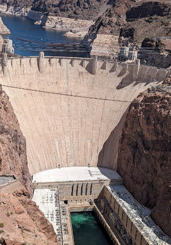
Currently, Lake Powell is 42% full, Lake Mead follows at 33%, and the Lower Basin is still under a Tier 1 shortage. Additional help through $4 billion in federal funding is also going to support new water conservation projects and financial incentives to cities to reduce their draw from the Colorado River, but more steps will likely be needed soon. “A lot of this interim stuff ends in 2026,” says Forrest. “They need to figure out a permanent solution or we’ll be right back where we were.” Porter notes that in 2026, new guidelines for managing the system will be implemented. “Those guidelines will likely detail what water users’ supplies will be cut — and how much — under various shortage conditions,” she says. “Climate change is here, and it’s not going away any time soon,” Berggren said. “The overall trend is less water in the system, so we have to plan for that.” Two strategies for addressing declining Colorado River supplies that are gaining momentum in Arizona include augmentation and recycling. Plans to ‘augment’ water supplies from the Verde River are already underway. The Bartlett Dam modification project aims to raise the height of the dam by 100 feet, allowing for more water storage capacity. Additionally, the City of Phoenix is leading plans to develop an advanced water purification facility that would treat effluent water to raise it up to drinking water standards, enabling the city to reduce its reliance on Colorado River water by as much as 50%. According to Porter, other cities may also invest in that project.
However, climate experts are predicting an 85% likelihood of 2025 being a La Nina year, which is typically hotter and drier, so the clock is ticking. Says Berggren, “Everyone is going to have to do their part — cities, ranchers, businesses, homeowners. We’re all going to have to share in the solution.”


